It was early June and a lot of snow had fallen in May. Our annual trip up Mitchell Peak showed a lot of snow remaining in the high country, but an early June trip looked possible. I hadn't been to the Blackcap Basin in a while and I was interested in a challenging warm-up trip, so the Blackcap Basin looked like a natural.
I started from the Rancheria Creek trailhead in mid-morning and soon I was moving past the prominent local landmark, Finger Rock.

Finger rock is the most memorable landmark of the first part of the trip.
I lost the trail to Crown Pass at a huge deadfall and dropped into the valley below Chimney Lake. After readjusting my route with the help of GPS, I made my way toward Chimney Lake where I enjoyed dinner.

Chimney Lake - After losing the trail at a huge deadfall, I ended up at Chimney Lake, a great spot for dinner.
I headed back toward the trail and considered spending the night at Woodchuck Lake. A flat ridge top tempted me to stop and set up camp before I was able to reach the turnoff. It was a fine site, despite the sometimes, overwhelming garlic odor wafting up from the swamp below.
Day 2
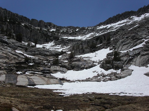
I was on the trail again the next morning before seven and soon passed the Woodchuck Lake turnoff. Patchy snow became more common as I moved up toward Crown Pass.

Snowy Ridge - The higher ridges on the way to Crown Pass were partly covered in snow.
I reached the pass at about 8:30 and an hour or so later I was at the turnoff below Halfmoon Lake and heading to the North Fork of the Kings River. The trail to the North Fork was littered with deadfalls which made travel slow at times. Fortunately, someone had placed ducks in the worst areas. After a tedious couple of hours, I could hear the roar of the Kings as I made the final descent into the valley.

North Fork Kings River - After winding around dozens of deadfalls, I made the river at around noon.
After a long rest, it was back to the trail, or was it the swamp. Very little dry trail existed. Either the path was a puddle or a stream. What appeared to be perfect conditions for mosquitoes had not yet spawned many of them. By three in the afternoon, I had reached the turnoff to Crown Valley. I walked a few steps farther and sat down on the benches at a large packers camp where I shook the rocks out of my shoes and took a long break. The meadow below was flooded by spring runoff. Yearning for a more scenic camp spot, I moved up stream to Portal Lake. My original plans included visiting Midway and Cathedral Lakes, but the route into the basin looked too dangerous due to snow cover. With several hours of daylight remaining, I thought it would be a good idea to push on to Pearl Lake. By the time I got half way there, I reconsidered leaving Portal Lake. Portal was such a beautiful spot and there was no one around, so I decided to return and camp there. I spent a couple of hours before and after dinner taking photos and shooting videos.
Mountain from Portal Lake - I took a lot of videos of this peak and the surrounding ares with my new digital camcorder. The videos are fun to look at but I'm not sure the weight of the camcorder makes it worth carrying.
Day 3
After an excellent night's sleep, I got an early start and again headed toward Pearl Lake. I crossed patches of snow and walked by frozen puddles and ponds.

Large Ice Crystals in Frozen Pond - On the way to Pearl Lake, I crossed a large, frozen meadow. Most shallow bodies of water had a skin of ice on them.
Soon, Pearl Lake appeared after scrambling up a short ridge.

Pearl Lake - Parts of Pearl Lake were covered with ice and snow.
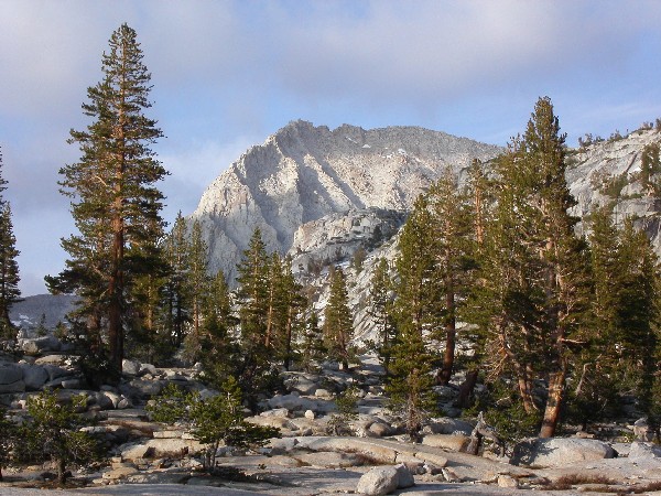
After contouring around the west end of the lake and walking up another small ridge, I was looking down on Division Lake which seemed to have broken winter's grip.

Division Lake - Even though Division Lake is more than 100 feet higher in elevation than Pearl Lake, it had no ice cover.
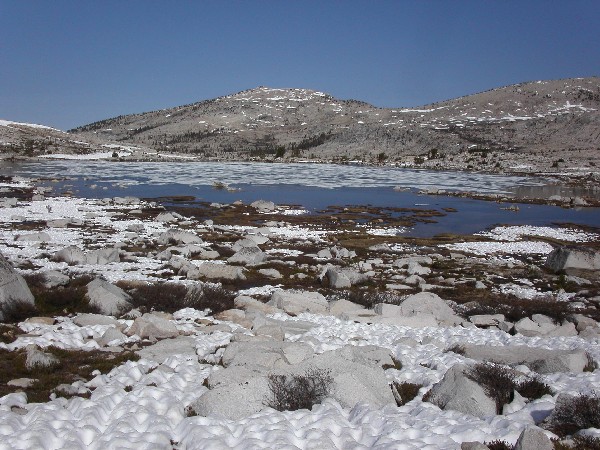
Right next to me was Regiment Lake, still frozen and slick with ice.

Regiment Lake - Regiment Lake at almost 11,000 feet elevation, was almost completely frozen over.
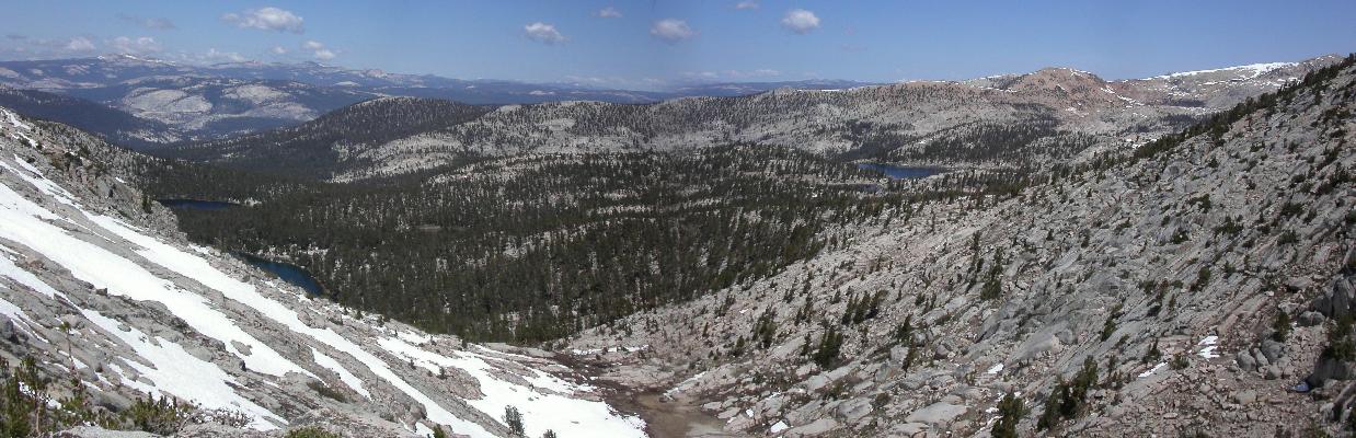
As I moved across snow and up the ridge on the way to Bighorn Lake, I looked back to the south and spied frozen Battalion Lake beneath an impressive peak.

Battalion Lake, nested beneath Peak 12,323, wasn't even visible because of snow and ice cover. Magnificent Finger Peak is in the right background.
The route across the divide was mostly snow covered.

Snow Cover on the way to Bighorn Lake - I crossed a lot of snow with well-developed snow cups on the way to Bighorn Lake.
The snow was firm enough to support and not so frozen that it was slippery. An oasis of renewed life appeared in the middle of the huge snow field.

Spring Pool on the way to Bighorn Lake - A small pool of spring appeared as I crossed the pass.
Soon, Bighorn Lake burst into view and I saw the pass I would have to cross in a couple of hours.
Bighorn Lake - Bighorn Lake was the last named lake I saw as I left the Blackcap Basin. On the horizon was my next goal, Blackcap Pass which is to the right of Blackcap Mountain.
This side looked easy and snow-free as I knew it would. I was very nervous about the other side of the pass and knew I would have to turn around if it was choked with snow.
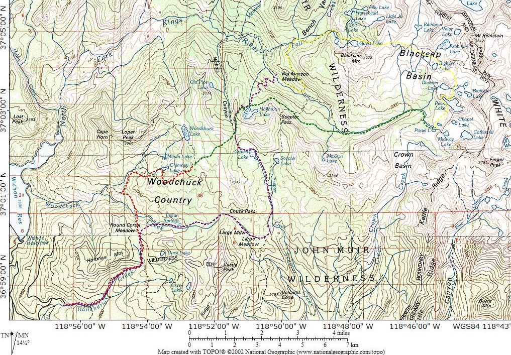
A few hours later, I was standing on Blackcap Pass and enjoying the view of the lakes below and the mountains in the distance.
Panorama from Blackcap Pass - To the left are McGuire Lakes and Guest Lake. On the right is Horsehead Lake. The peaks of the Dinkey Lakes Wilderness are in the distance to the left.
I took my time descending the steep west side of the pass which was much more difficult because of the snow cover.
Blackcap Pass from the West - Snow at the top of the pass made the going slow.
I picked up trail at Guest Lake and dropped into the Kings River Valley again. This time as last, the trail was littered with deadfalls and looked as if it hadn't been maintained in several years. I finally reached the river trail a little after four and headed downstream to Big Maxson Meadow.
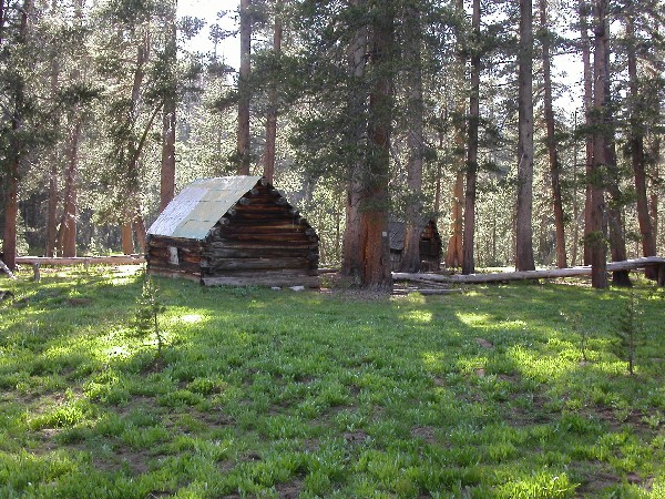
Maxson's Big Meadow - I stayed next to these cabins on my third night out.
The river crossing looked much less difficult than I had imagined it would. I decided to stay near the cabins because the meadow was relatively mosquito free.
Day 4
The morning of the fourth and last day, I crossed the river at about 6:15. I spent the next 45 minutes looking for the trail which turned out to be upstream of where I thought it would be. The trail turned out to be very well maintained and had some great views across the valley.

Blackcap Mountain and Mount Goddard - On the trail from Maxson's Big Meadow to Halfmoon Lake, I spotted Blackcap Mountain sitting directly in front of Mount Goddard.
By 8:40 I had reached Halfmoon Lake and by ten I was at Crown Pass looking at Crown Lake below. I split off from the trail I came in on and headed to Crown Lake which I fully expected to be infested with mosquitoes. However, it was not and the walk by the lake was very pleasant.

Crown Lake with its nearby swamp, should have been mosquito heaven. I didn't see any on this early season trip.
The rest of the trip was a tiring slog through forest and meadow (aka swamp) with occasional interesting diversions such as mossy pools.

Indian Springs - This was one of the many treats that I passed by as I returned to the trailhead.
After several days without human contact, I met a pair of couples just below Chuck Pass. The rest of the trip had been in complete solitude.
What is good about early season trips? Even if you go to popular areas, you aren't likely to see a lot of people. You can camp in places that you would never choose otherwise, because no one is around to disturb you. Mosquitoes are surprisingly absent. Snow and swamp make the going slow but they give the high country a different look.
15585
One Page Version 23 January 2013