Day 1
I started climbing the switchbacks of the Copper Creek Trail during the midafternoon when the thermometer read somewhere between 95 and 100 degrees. I camped at Lower Tent Meadow for the first time since 1957.Day 2
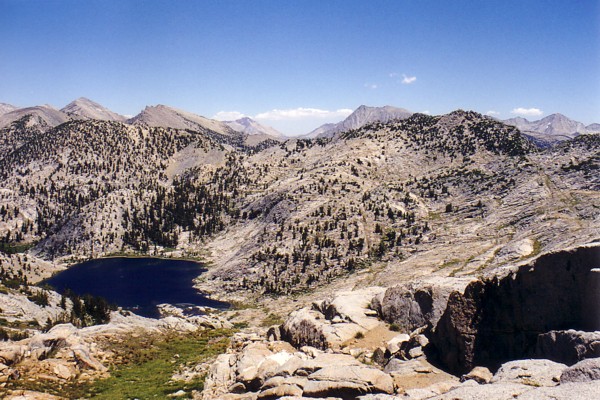
After a warm night's sleep I was on my way to Grouse Lake and the passes beyond. The walk went smoothly but more slowly than expected. There were great views from the basin between Monarch Divide and Goat Crest.
Grouse Lake Pass - Here's an interesting look at the north side of Grouse Lake Pass from one of the small lakes between Goat Crest and Monarch Divide.
I enjoyed the view of the pond on Goat Crest Saddle

Goat Crest Saddle - This small pond on the pass forms the foreground for the Palisades to the north.
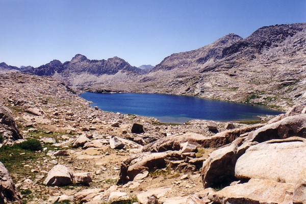
and down into upper Glacier lakes.
Upper Glacier Lake - The great view of Upper Glacier Lake includes Taboose Pass in the distance.
Instead of making it to my planned destination of Windy Ridge, I had to settle for Horseshoe Lakes.

Upper Horseshoe Lake - There are great campsites at this string of lakes.
Day 3
The next morning was spent traveling through familiar territory; across Windy Ridge,
Windy Ridge - This is where I planned to stay on the second night of the trip. Someday, I will.
across Gray Pass, by Cirque Crest,

Cirque Crest - This basin has a very remote feel. The nearest maintained trail is miles away.
over Red, and White Passes and down to Marion Lake.

Marion Lake - This is considered by many as the premier destination of Lake Basin.
Despite having been through the Lake Basin a couple of times, I went the wrong direction and wandered around in circles for a while before finding my way to the lakes west of Frozen Lake Pass.

Frozen Lake Pass - This pass is rated as one of the most difficult on the High Route. From west to east, it requires care but it is not that bad. Maybe it's worse when there is more snow.
I was too tired to go over the pass even though it was only a little after five o'clock. I set up camp, ate dinner, and went to bed early.
Day 4
All night long I dreamed about crossing Frozen Lake Pass then awoke to a frosty and crystal clear morning. I was atop the pass at 8:20 and stared down at "Frozen Lake" which wasn't frozen at all in this low snow year.
Frozen Lake - The lake wasn't frozen. Traveling the loose talus above and below the lake took a lot of time.
Going was slow down to the lake and beyond. Finally, I was at the JMT at a little before noon. Being surrounded by the masses of the JMT was a little unsettling. There must have been a dozen people enjoying the view from Mather Pass. The crowds thinned as I descended past Palisades lakes. A buck with a huge rack lounged near the lower lake.

Big Buck - I think this big buck thought he was invisible. He never batted an eyelash when I stopped to take this photo.
I found a great campsite above the lower lake outlet and below the grassy ledges leading to Cirque Pass.
Day 5
The next morning, I hurried up to Cirque Pass
Cirque Pass - From Potluck Pass, the north side of Cirque Pass doesn't look very easy but all you have to do is pick the right ledges.
where there was a great view of Lake 3559 and Potluck Pass beyond.

Potluck Pass and Lake 3,559 - From Cirque Pass, Potluck Pass looks like an impassable wall. Despite the lack of vegetation, there are some nice campsites in the basin.
When I reached the canyon floor, I took a photo of the lovely lake just below the main lake outlet.

Headwaters of Glacier Creek - Below the outlet of the main lake is this small lake with its nice beach.
I got a little carried away and climbed higher than necessary before downclimbing and traversing over to Potluck. The other side was an easy stroll past the beautiful Barrett Lakes
Lake 11,523 - The Barrett Lakes are quite scenic and just a short hop over Knapsack Pass from Dusy Basin.
and over a surprisingly well-built trail to Knapsack Pass.

Columbine Peak - I was impressed with the beauty of the lakes of Dusy Basin. The surrounding mountains form an impressive backdrop.
I decided against camping with the masses in lower Dusy Basin and camped at Lake 11,388 instead.

Lake 11,388 - I was impressed with the beauty of the lakes of Dusy Basin. The surrounding mountains form an impressive backdrop.
I was far behind schedule on this, my fifth day, and I wondered if I should continue toward Bear Dam or go out over Bishop Pass. As I was mulling it over, I ran into another hiker who said a decent hiker could make it from the vicinity of Muir Pass to Florence Lake in one day. I decided I'd bust on to Florence where I planned to hitch a ride to the Bear Dam road.
Day 6
The remainder of the trip was a real push but that's not to say that it wasn't enjoyable. LeConte Canyon was more beautiful than I remembered.
LeConte Canyon - The Middle Fork of the Kings River meanders through Little Pete and Big Pete Meadows which contain many lovely campsites.
I had never gone over Muir Pass from the south, so the views were quite different from my previous trip. It seemed like a lot more work than coming from the other direction. As the day grew short I passed by Helen Lake

Helen Lake - This scenic lake lies just below Muir Pass and it's named for one of John Muir's daughters.
then I reached the hut on Muir Pass where I ate dinner.

Rock Hut - The hut is still in good shape but I wouldn't want to stay there overnight unless there was a storm. It echos too much and it smells like a latrine.
There was plenty of light left, so I pushed on as far as I could, pitching my tent at Sapphire Lake.

Sapphire Lake - Evening light bathes Mount Fiske and Mount Huxley which reflect the alpenglow.