After walking parts of Steve Roper's Sierra High Route, it occured to me that it stopped short of passing through some of the range's finest high country. This inspired me to put together a route that would continue the route to the south. I decided I would extend the route from roads end near Cedar Grove to Mineral King. The trip (
see map) would remain off trail as much as possible and much of it would pass through central Sequoia National Park.
Sprinkles the night before had cleared the air so I began the hike on an exceptionally beautiful day. Although I had ascended the switchbacks next to Bubbs Creek many times before, it seemed like there were a few extra this time. I left Bubbs Creek at the Sphinx Creek Bridge and ascended the steep trail carved into the dome east of Sphinx Creek. In the early afternoon, I left the trail and began the cross country climb up the west side of Sphinx Creek. The path followed faint trail and a few ducks past a lower then a second lake and finally I had my pick of the several campsites at Sphinx Lake 10,514.

Sphinx Lake 10,514
After catching a couple of trout for dinner, I enjoyed the awesome scenery then got a good night's rest.
The next morning, I began my ascent to Sphinx Col, the first of three cross country passes I would cross that day. The route passed by several more crystal clear lakes before a long slog through talus. Lovely clumps of yellow columbine decorated the way.

Yellow columbine on the way to Sphinx Col
By midmorning I was atop the pass looking at the grass-cushioned slope leading to the Cinder Col.

Cinder Col connects Brewer Basin to South Lake
Mount Brewer dominated the view.

Mount Brewer from the northwest
As I descended through the Brewer Basin, I passed by lush stands of monkey flowers.

Monkey flowers in Brewer Basin
A little before noon I was atop my second pass for the day and descending toward South Lake at the head of Cunningham Creek where I took a brief lunch break.

South Lake from the southeast
A short distance to the southeast of the lake was my next destination Longley Pass which connects the head waters of Cunningham Creek

Longley Pass from the west
with the headwaters of East Creek

Headwaters of East Creek and unnamed lake above Lake Reflection
which also contain Lake Reflection.

Lake Reflection
After six years of drought, the cornice which usually stretches across Longley Pass had shrunk to a small patch of snow making the crossing exceptionally easy.

Longley Pass from the east
On the way down to the lake, a marmot posed for the camera.

A fearless marmot posed on a rock near a tarn above Lake Reflection
Remnants of old trail passed by clumps of rock fringe.

Rock fringe grows next to the old trail leading to Lake Reflection
A Boy Scout troop occupied the campsites next to the outlet, so I crossed the outlet and followed the non-maintained trail toward Milly's Foot Pass. When I could no longer hear the scouts, I found camp spot next to a creek, dined, bathed in ice water, and got a good night's sleep.
I was up early the next morning which allowed me to cross Milly's Foot Pass by mid morning.

Milly's Foot Pass from upper Kern basin
I descended into the upper Kern basin toward the Lake South America trail and noticed that Kern Canyon was filled with smoke.
Fortunately the smoke hadn't worked its way into the Upper Kern basin
When I got to the trail, I took a lunch break then hiked toward Milestone Basin. At the next trail junction, I stopped briefly at the camp I had used as a Boy Scout in the early 1960's.

Lake where Boy Scouts of Troop 152 camped during the early 1960's
The area was now off limits to camping due to overuse. Not long after leaving the old camp I arrived at the Milestone trail. Milestone Mountain is at its most impressive from the basin and I moved toward it and then toward Milestone Pass which is just south of the peak.

Milestone Mountain from Milestone Basin
I took pictures of Milestone Basin

Milestone Basin
and Milestone Bowl while on the pass
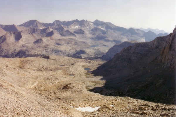
Milestone Bowl with the Kaweah Peaks on the skyline
then descended through the bowl to a clump of pines growing on a moraine south of Colby Pass where I spent another beautiful evening.

Milestone Pass from Milestone Bowl
I watched a Mount Pinatubo sunrise from the comfort of my sleeping bag early the next day. It was a dry, clear, mosquito free morning. My laundry from the night before was almost dry. From my camp, I could see the route up a ridge which would lead me to Triple Divide Pass and Peak.

Ridge that leads from the Colby Pass trail to Triple Divide Pass and Peak
I had noticed the potential route on an earlier trip but had never tried it. It turned out to be a lot easier than I had expected

View of the route up from the Colby Pass trail
and I even encountered a few ducks on my way to the top of the ridge where I had great views of Colby Pass,

Colby Pass, Centennial Peak, Milestone Peak and Pass from the ridge
the Kern-Kaweah River,

Kern-Kaweah River from the ridge
the passes into Nine Lakes Basin,

Kern-Kaweah Cols from the ridge
and Triple Divide Peak and Pass.

Triple Divide Pass and Peak from the ridge
My route went north along the ridge, passing tiny lupines near a small lake,

At high elevations, lupines tend to be small
then descending to the valley leading up to Triple Divide Pass. Instead of heading directly for the pass, I ascended to the ridge east of the peak. I dropped my pack when I came even with the pass then headed to the summit.

Benchmark on Triple Divide Peak
It was a beautiful day with great views of the Kaweahs,
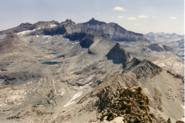
The Kaweahs from Triple Divide Peak
the Whaleback,

The Whaleback from Triple Divide Peak
Coppermine Peak/Pass,

Coppermine Peak/Pass from Triple Divide Peak
and the Great Western Divide.

Great Western Divide and Triple Divide Pass from Triple Divide Peak
I returned to my pack, dropped down to Triple Divide pass and made my way toward Glacier Lake.

Glacier Lake from the east
From there, I made a steep traverse toward the tarn below Lion Lake Pass and was soon on top.

The tarn and Lion Lake Pass
There was an excellent view of the Lion lakes, Black Kaweah and my next pass, Lion Rock Pass.
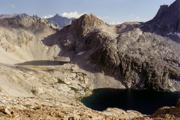
Black Kaweah, Lion Lakes, and Lion Rock Pass
I made camp between the two lakes and although the wind howled all night long, I had a comfortable night's rest.
The next morning, I didn't like the looks of the loose talus above upper Lion Lake, so I decided to try a route up the small stream that empties into the west side of the lake. The route was easy and headed south to the pass which led into Nine Lakes Basin.

Lion Rock Pass from Nine Lakes Basin
Soon I was traveling on trail down the Big Arroyo. At the patrol cabin, I ascended to Little Five Lakes where I took a break and admired the fabulous view of the Kaweah Peaks.
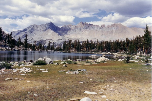
Kaweah Peaks from Little Five Lakes
Next was Black Rock Pass where there is marvelous view of the headwaters of Cliff Creek.

Columbine, Cyclamen, and Spring Lakes, the headwaters of Cliff Creek from Blackrock Pass
Glacier Pass looked free of snow so I looked forward to an easy crossing.

Glacier Passfrom Blackrock Pass
After descending most of the switchbacks down from Black Rock Pass, I left trail and walked to Spring Lake where I spent my last night.
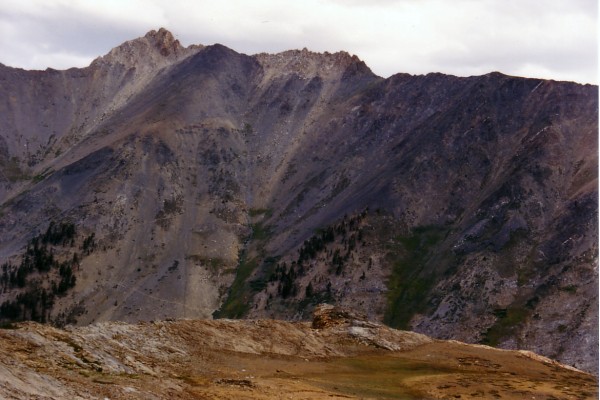
Black Rock Pass from the west
The next morning, I spent a couple of hours catching a limit of brook trout from Spring Lake then began the climb to Glacier Pass.

Glacier Pass from above Spring Lake
I packed the trout in some snow that I found near the pass then descended the old trail down the north side of Monarch Creek. Although it has been abandoned for decades, it is still passable and allows views that are superior to those from the new trail that goes up the south side of the valley. I arrived at the trailhead in the early afternoon where I was picked up by my wife and children who were happy to get a break from the 105 degree temperature of the San Joaquin Valley.


