After surveying the damage, I kicked back for the rest of the morning and visited with a Sierra Club outing group that was camped nearby. I was hoping the sun would break through enough to dry out my bag but when it didn't, I returned to Crescent Meadow that afternoon. I wasn't interested in spending the night in a damp sleeping bag.
Day 1
The morning of August 1, it was deja vu. I was back at Lodgepole Visitor's Center getting another wilderness permit for the trip I had abandoned just a week earlier. This time the weather was more cooperative. The first day was beautiful. Even though the valley of the Kaweah was hazy, it was sunny all day.I was on track to make Precipice Lake as I crossed Mehrten Creek at mid-morning.

Mehrten Creek has scoured the valley wall to bedrock and produced one of the most pleasant rest stops on the first section of the High Sierra Trail.
The sky cleared enough to see nearby Little Blue Dome with the lofty peaks of the Great Western Divide in the distance.
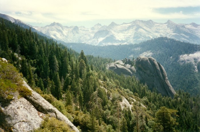
Lots of snow covers the western slopes of theGreat Western Divide even though this photo was taken in August. Little Blue Dome is in the midground while the north edge of Sugar Bowl Dome can be seen on the right side of the next ridge.
Just before noon, I stopped at my favorite rest stop in the valley.

From this rock bench, Little Blue Dome can be seen in the canyon below. The comfortable back rest and peaceful ambiance make this one of my favorite stops.
Early that afternoon, I visited with the trail crew who were building a bridge over Buck Creek.

A trail crew was busy doing concrete work on the new bridge over Buck Creek. Buck Canyon suffered extensive erosion late in 1996. Much of the canyon was scoured to bed rock. Storms dropped record amounts of precipitation during the months of November and December.
Winter storms caused extensive erosion in Buck Canyon and wiped out the old crossing. I blew through Bearpaw Camp, stopping long enough to take a photo of a couple of

A couple staying at the High Sierra Camp was kind enough to pose for a photo in front of the million dollar view. I had been here a week earlier and it was so cloudy the view wasn't worth a nickel.
High Sierra camp guests with the million dollar view in the background. The next part of the trail is my favorite and I was rewarded with exceptional views to the head of the Kaweah River Canyon.

My favorite section of the High Sierra Trail is between Bearpaw Meadow and Lonepine Creek. The trail hangs on the side of the canyon and views like this are common for much of the way. Wildflowers in hanging gardens are especially plentiful as well.
That evening, I ate dinner at upper Hamilton Lake, enjoying the magnificent surroundings and watching small trout jump for mosquitoes. Then it was off to Precipice Lake, a few miles and a considerable climb from Hamilton. I took it pretty easy that evening, stopping now and then to take photos, including one of Eagle Scout Peak.

The sun dropped low in the western sky and shadows lengthened as I made my way from Hamilton Lake to Precipice Lake. Eagle Scout Peak stood prominently in the distance. I hoped to climb the peak from Big Arroyo on the next day.
Each bubbling spring, there were more than I ever remember seeing, was an excuse to stop and rehydrate. Finally, I arrived at Precipice Lake and succeeded in finding a campspot with the help of a flashlight.
Day 2
After an excellent night of rest next to Precipice Lake, I hit the trail early and made Kaweah Gap at around 7:30.
The water and algae stained cliff on the far side of the lake intrigues everyone who visits here. I was surprised to see ice on the lake in August. The trail between here and Kaweah Gap, was covered with snow in places, also.
The trip to the gap was slowed by lots of snow in places I had never seen snow in August. I spent the rest of the morning in an unsuccessful attempt to climb Eagle Scout Peak. My first mistake was in trying to contour around to the approach from Kaweah Gap rather than dropping down into the Big Arroyo. I had to retrace my steps when I reached some steep rock and I ended up spending most of the morning getting to the base of the mountain. At the halfway point of the ascent, I realized that if I continued the climb that I wouldn't make it comfortably to that night's destination, so I bailed out and returned to the Big Arroyo. The Big Arroyo was especially lush for this time of year.

The floor of Big Arroyo was green and lush. I saw no one in this valley or anywhere else on the trail between Precipice Lake and Moraine Lake.
Creek crossings were more numerous and trickier than in past years. A half dozen streams flowed off the flanks of the Kaweah Peaks that were not shown on the topo map. I became concerned about my return route. I had hoped to return via Kaweah Basin and Pyra-Queen Col, but it seemed likely that there would be too much snow to make it a safe route. I would have to scope out the proposed route from the top of Mt. Whitney in a few days.
The trail continued up to Chagoopa Plateau. There were excellent views of the Five Lakes country to the west across the Big Arroyo.

The Great Western Divide remains impressive in the view from the western edge of the Chagoopa Plateau, the world's largest campground without people.
Finally! I was up on the plateau and heading toward camp. I stopped briefly at the turn off to Moraine Lake to take a photo of Big Kaweah.
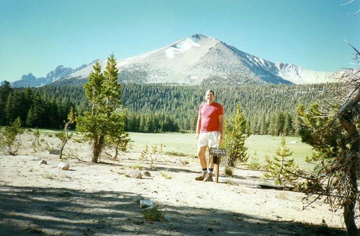
Massive Mt Kaweah is at its most impressive from the northern trail junction on Chagoopa Plateau. If you want to enter Kaweah Basin via Kaweah Pass, this is a good place to start contouring east to Chagoopa Creek. Follow the east fork of the creek to the pass.
At 6:30, I arrived at Moraine Lake.

Even though Moraine Lake is highly touted in trail guides, I was prepared to be disappointed. After all, this is a lake surrounded by heavy forest. I was very pleasantly surprised by its charm and peacefulness.
What a pleasant surprise. I expected something a lot less lovely than this gem of the forest. There are numerous fine camping spots and a bear box to boot.
Day 3
The day dawned cloudy, but I didn't waste any time worrying about the weather that day because the views across the lake were so beautiful. To the southwest, the distant ridge was bathed in a pinkish-golden glow and perfectly reflected in the lake.
I felt a little uneasy watching the clouds build so early in the morning. The lighting was awesome and it was beatifully reflected in the calm of Moraine Lake.
To the west, the forest on the far side of the lake caught a sliver of light that sliced through the building clouds.

I clicked off another shot of the approaching storm and figured I'd better hit the trail and put in as many miles as possible before it started raining.
The clouds remained fairly high as I passed by Sky Parlor Meadow.

Not only were there few humans on the Chagoopa Plateau, I didn't see many other animals despite the lush vegetation and abundant cover.
A little bit later the trail began dropping off the plateau, making its way down the Funston Creek valley. A covey of mountain quail played tag with me part of the way down. Finally, the huge canyon of the Kern River came into view.

I expected the trail down Funston Creek to be much steeper than it turned out. Unlike the Chagoopa Plateau, however, Funston Creek valley was full of wild life. Clouds continued to build and I mentally prepared for some delays due to showers.
Before I knew it, I was walking up the Kern and passing by lovely Chagoopa Falls.
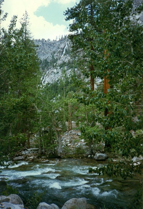
The walls of Kern Canyon make the perfect backdrop for Chagoopa Creek as it leaps over the edge of Chagoopa Plateau and cascades into the valley to join the Kern River.
My next stop was unplanned and entirely enjoyable. I had bathed at Kern Hot Spring several times in the past but was not sure I had the time for it this time.

Every time I have visited this hot spring, the facilities have had a different look. The tub is perpendicular to the river now, whereas last time I visited (1970) it was parallel to the river. The first time I was here (1960), the tub was housed in a small cabin.
A hiker who was just getting out of the tub as I passed by convinced me it would be a good idea to take a break and he was right. I really enjoyed the soak.
Showers fell off and on that afternoon, slowing my progress up the Kern River canyon.

When I think of the Kern River Canyon, I think of stretches of trail that look like this.
Whitney Creek crossing was unbelievable. There was so much water coming down the valley that it spilled onto the trail and covered it for several hundred feet north of the main crossing. I ate dinner at Junction Meadow among Boy Scouts from Troop 85 of Fresno.

Scout Troop 85 of Fresno was camped at Junction Meadow. We chatted about plans and trail conditions, especially the harrowing crossing of Whitney Creek. I saw them again between Wallace Creek and Sandy Meadow as I was hiking out to Cedar Grove.
After dinner, I pushed up the trail as the sun melted away behind clouds near Kaweah Peaks.
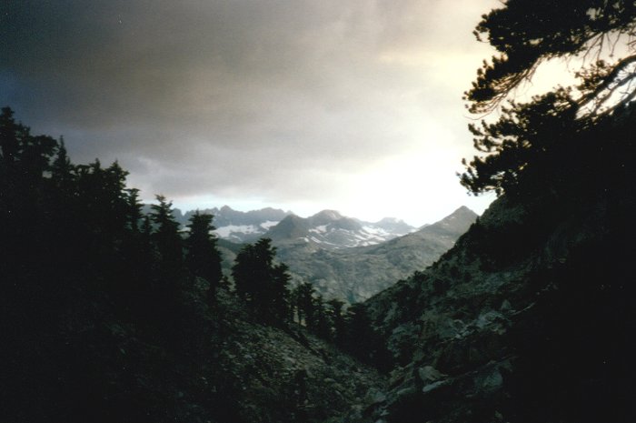
Showers continued to fall as I hiked up Wallace Creek. One nice thing about the cloud cover - it helped to produce some nice sunsets.
The fording of raging Wright Creek, muddy from the afternoon's showers, was the most exciting event of the evening. I made it to that night's camp as the last light was disappearing from the cloudy sky. Water dripped from trees onto my bivvy sack all night long, but it didn't prevent me from getting a good night's sleep.
Day 4
I got an early start and passed by the hikers at the main camp area near the bear box before most of them had stirred from their tents. I t was a lovely clear morning and before I knew it, I was talking to Crabtree Meadow Ranger Rob Pilewski. An hour later, Rob reminded me that I wanted to go up Mt Whitney and if I wanted to do it today I'd better get up the trail. I stowed my pack in the world's biggest bear box and moved toward the summit. Clouds were starting to build around the massive mountain as I began my ascent.
What a beautiful day to hike up Mt Whitney. There were very few people on the trail until I reached the ridge top.
I passed a few people between Crabtree and Guitar Lake, then saw no one else until I got to the trail junction on the crest. I met many people on the way to the summit. A wall of clouds was streaming up from Owens Valley and covering the summit at times. I heard no thunder, saw no lightning and could think of no decent excuses to turn back, so I continued up the trail. As I got to the rock shelter at the summit four Arizonans were celebrating their triumph and signing the register. I got them to take my photo next to the shelter.

It felt good to be on top. Clouds came and went, directing our sights this way and that. After a half hour or so, I was ready to make the descent.
Photo opportunities were limited because of cloud cover, but I managed to get a good shot to the northwest.

A sizable snow patch remained on the summit. I got carried away by the incredible lighting and walked far west of the trail. I had to cross several hundred feet of the snow field in order to return to the trail.
The descent was made more exciting than usual by a hail and rain storm. In between showers, I managed to photograph some lovely purple

Clumps of Polomonium eximium, aka skypilot, decorate the trail at its higher elevations.
and golden alpine flowers.
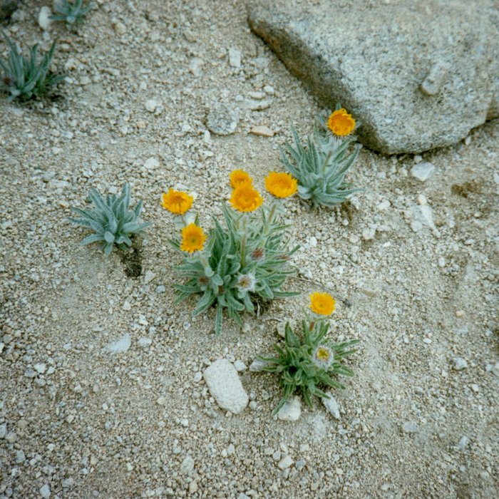
Clumps of Hulsea algida, aka alpine gold, decorate the trail at its higher elevations.
I was happy to be off the summit since thunder claps were crashing from that direction. A lone coyote called from Hitchcock Lakes. As I passed by Guitar Lake, all the campsites were filled and their occupants were very concerned about tomorrow's ascent.

Hail and rain showers fell during the descent of Mt Whitney. At Guitar Lake, the sky looked very threatening. Thunder claps were coming from the direction of the summit. Soon, however, it began clearing.
It didn't look like it would be bad because the sky began to clear as I passed the meadows above Timberline Lake.

By the time I got to this lush meadow, it looked like it might start clearing. Everyone I met on the descent asked me what I thought the weather would be like for their ascent the next day. I guess they thought I had visited a sage on the summit.
I found a spot under the trees at the Crabtree Meadow "village," ate dinner and enjoyed an excellent night of sleep.
Day 5
This day dawned without a cloud in the sky. As I passed by Sandy Meadow, it was hard to figure out where it got its name.
Sandy Meadow was greener than usual.
I crossed paths with Troop 85 again and made it to Wallace Creek at around lunch time. Yoav and James were sitting on the bear box where they had set up the "Wallace Creek Deli".

Yoav and James invited me to join them for lunch. Yoav was about ready to complete the entire John Muir Trail. James came in over Kearsarge Pass to join Yoav for the last leg of the trip. They were eating well and I really enjoyed the food and their company.
We struck up a conversation and they gave me a pita pocket filled with hummus and cheddar cheese. Wow, was it great. Since they had brought too much food, they talked me into taking a brick of cheddar and a bag of crackers.
I passed lots of hikers that afternoon. Views of the Kaweah Peaks convinced me not to try going home that way.

The clouds didn't block the distant views most of the time. Heavy snow fields at the foot of the Kaweah Peaks discouraged me from returning via Pyra-Queen Col.
I briefly considered retracing my steps, but decided to go out to Cedar Grove instead even though I would have to get a ride back to my car at Crescent Meadow. Thunder clouds began to build again as I passed over the Bighorn Plateau where I enjoyed a spectacular view of the Great Western Divide.

I was tempted to spend the rest of the day on the Bighorn Plateau, a magical place with marvelous views in all directions.
I shared cheese and crackers that evening with two Marines from San Diego and their two partners. It was a great end to a leisurely eight mile day.
Day 6
Another beautiful day was in the making as I hit the trail toward Forester Pass and soon was above timberline. I headed past the frog ponds.
The surface of the Frog Ponds sparkled far below the John Muir Trail where I was now hiking. I suppose it was because the frogs were happily jumping around, but I'm not sure. I was too far away to tell.
Suddenly, dozens of birds flocked in and around the rocks. Their chirping became more excited than usual. I soon saw the source of all the excitement, a small white-to-cream-chested raptor (falcon?) who took off after some of the birds as soon as I spotted him. One of the small bird gave chase. The "falcon's" wing speed was very rapid.
Clouds began to build up as I got closer to Forester Pass.

I was a little concerned about crossing Forester Pass. I had heard that there was a tricky snow field close to the top on the south side. Fortunately, the crossing wasn't bad at all.
At the base of the switchbacks, I met the first group of the day after having hiked alone for several hours. There was a little snow on the trail but not enough to cause any problems. There was a crowd at the top of the pass and I got one of them to take my photo next to the sign.

There was a real crowd at the top of the pass and I got a volunteer to take my picture. I guess it's time to: 1. change my shirt and 2. go on a diet.
The north side of the pass was much snowier
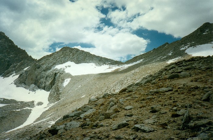
More snow than ususal below Forester Pass in August.
and the trail made a major detour around a 30 foot high cornice.
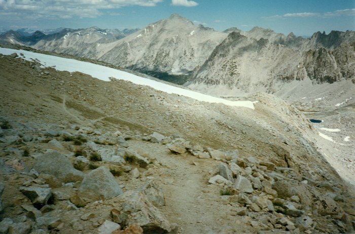
A long cornice on a ridge below the pass covered the trail making a slight detour necessary. As I came closer to it, I saw several people looking down from the top of the cornice scratching their heads as if they were wondering how to get down. I met them at the low end of the cornice and they were happy to learn that the detour I had come down was the way to the pass.
The trail was almost snow free below the cornice. Although it clouded up again that afternoon, very little rain fell so progress was good.

Another cloudy afternoon. I was lucky. Showers were spotty and light where I was but others I met ran into heavier rain down the valley.
I had dinner at Bullfrog Creek. There must have been 20 tents near the middle Vidette bear box, so I pushed on to lower Vidette. I was the third and last party to arrive there that evening. I spent a wonderful evening around the campfire with David Ericksen and family. A bear dropped by just before sundown but we chased him toward middle Vidette. A half hour later, we could here the campers at middle Vidette whoop and holler when the bear arrived. He had a lot more to choose from up there so we didn't see him again that night.
Day 7
I got up as early as I could so I could have plenty of time to catch a ride from Cedar Grove to Grant Grove. By the time I got to Grant Grove, it was 2:40, so I called home and asked Karen if she wanted to pick me up and take me to my car at Crescent Meadow or if she wanted me to continue hitch hiking. Thank God she said she would meet me. She brought the whole family who were happy to escape from 100+ temperatures in the valley and we had a mini-vacation for the rest of the day in the cool forest.
September 25, 1997
Revised 16 October 2012
One Page Version 29 January 2013