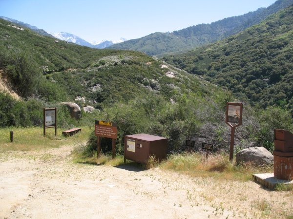
This is the view up the Middle Fork Valley from the trailhead.
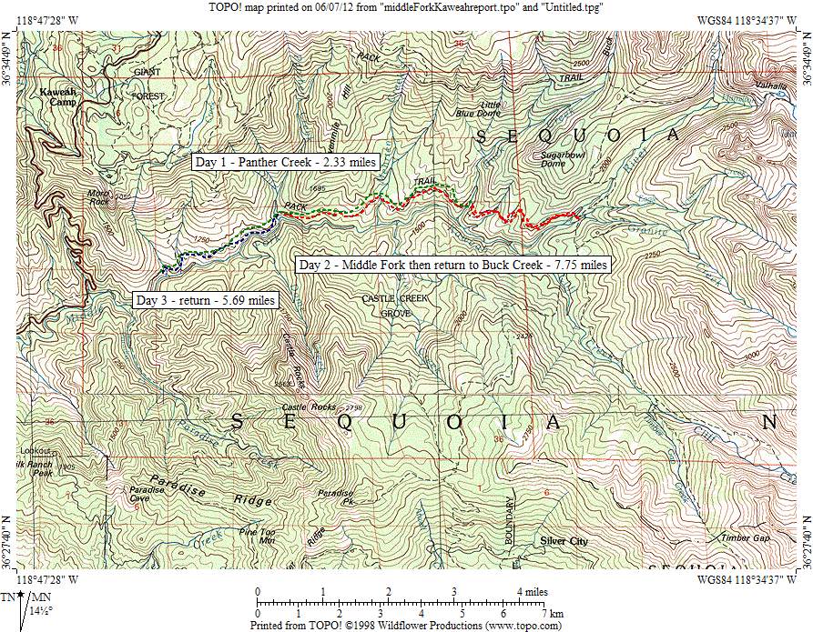
Day 1
Wildflowers are abundant and much of the trail is shaded by oaks and then mixed forest. Views of Castle Rocks
Castle Rocks dominate the view across the river.
and Moro Rock dominate the skyline to the south and north.

Moro Rock rises above the trail at the beginning of the hike.
Manzanitas on this lower part of the trail

Manzanitas are a big part of the chapparal community that dominates the lower parts of the trail.
had already dropped their blossoms.

Manzanita blossoms cover the trail in the lower sections.
Yuccas were almost in full bloom.

These beautiful plants are seen only on low elevation hikes.
The trip seemed to go slowly, probably because I stopped all the time to examine flowers, some of which I had never seen before. By mid-afternoon, I had reached an unnamed creek with several nice tent sites above. I had a feeling it wasn't Panther Creek because of its small size.

A nice stream with campites above could be a stop for those who get a late start.
I trudged up the trail a couple more hours, hoping not to come in contact with the abundant poison oak.

Be careful of poison oak on the lower sections of trail.
Finally, I arrived at Panther Creek and decided to camp there, even though I probably could have made it to Mehrten Creek.

Panther Creek is usually the first camping spot along the trail.
Indian pink was growing in several places around the camp, giving it a cheerful ambiance. The trail crossed Panther Creek very close to the Middle Fork where it plunges into the roaring river below.

Indian pink, Silene californica, is abundant near Panther Creek.
Day 2
I got on the trail early the next morning and passed by stands of kit-kit-dizze,
Kit-kit-dizze, Chamaebatia foliolosa, lines the trail in some sections.
soap plant,

Soap plant, Chlorogalum pomeridianum, is abundant along certain sections but it was not quite in bloom.
and chia.

Patches of chia, Salvia columbariae, added color.
I waded the sandy ford of Mehrten Creek and continued up to Buck Creek.

This is the sandy ford of Mehrten Creek.
Low and behold, there was a bridge across Buck Creek.

There is a bridge across Buck Creek.
Just across the creek was a nice campsite where I returned later that day.

A fine campsite is found on the other side of the Buck Creek bridge.
I stopped for lunch, then continued up the shady trail that was lined by wild ginger

Wild ginger, Asarum hartwegii, dominates the floor of the shady sections above Buck Creek.
with its strange brown flowers.

A close up of the interesting brown flower of Hartweg's wild ginger.
Manzanitas at the higher elevation were still in bloom.

At higher elevations, manzanitas have not yet dropped their blossoms.
The trail climbed via a few switchbacks then descended to the trail junction which branches toward Bearpaw Meadow. The trail continued dropping steeply toward the Middle Fork, with closer views of the Great Western Divide.

Descending toward the middle fork bridge, the Great Western Divide looms a lot closer than at the beginning of the hike.
Finally, I arrived at the river and found another bridge.

The Middle Fork bridge crosses a roaring river in the spring.
I crossed a low ridge to Granite Creek to find a lovely campsite next to the creek.

A fine campsite is found next to Granite Creek.
No bridge was evident and the water was deeper than I wanted to ford. I scouted around for a few minutes and found the remnants of a bridge that had washed away.

All that remains of the Granite Creek bridge are a couple of abutments.
On my way back to the middle fork, I noticed a trail going up the ridge. It's not shown on the park brochure map, but aparently the trail connects with a bridge over Granite Creek a mile or so away. That evening, I returned to Buck Creek.
Day 3
On the trip out, I promised myself not to spend much time taking photos. I took my time on the way out, waiting until the trail was mostly in shadows. It was hard to resist taking a picture of a small garter snake with a subdued lizard in his grip.
I wonder if the garter snake was able to get him down.
Also, I found a couple of interesting flowers I had never seen before, broom-rape

This showy broom-rape, Orobanche fasciculata, slowed my progress on the way out.
and purple fairy lanterns, so I had to take photos of them, too.

Fairy lanterns, Calochortus amoenus, were the last distraction on the way out.