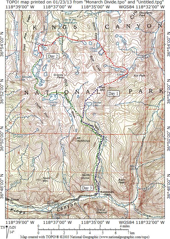
Day 1
I didn't get started until 9:40, but I felt good as I ascended the steep Copper Creek trail. It was my third trip of the year so I felt pretty good as I made my way thorough mixed pines and oaks. During a rest break, I took a photo of the Grand Sentinel across Kings Canyon.
Grand Sentinel - From the lower switchbacks of the Copper Creek trail, impressive Grand Sentinel dominates the south wall of Kings Canyon.
Toward the top of the lower switchbacks, I took another shot across the canyon, this time of The Sphinx.

The Sphinx - The view across Kings Canyon includes The Sphinx on the near ridge and the north end of the Great Western Divide including Cross Mountain, Mount Farquhar, and North Guard.
At the first water break, I had to fend off a small sow bear and her cub who attempted to get a handout. During lunch break at Lower Tent Meadow, I talked to a couple from Sacramento who had recently taken up hiking and were really impressed with Kings Canyon. The next stop was Upper Tent Meadow where I took a photo of the trail that zigzagged through the flowers and meadow below.

Upper Tent Meadow - The flower gardens of Upper Tent Meadow fill the near view while far below the huge switchbacks of the Copper Creek trail zigzag up the valley.
The ascent through the red fir forest above the meadow was accompanied by great views of the Gardiner Basin to the east.

Gardiner Basin - There are marvelous views of the peaks of Gardiner Basin through the towering giants of the red fir forest above Upper Tent Meadow.
At the crossing into Granite Basin, I headed cross country to Grouse Lake.

Grouse Lake - Munger Peak, Mungoat Pass, and Goat Peak form the backdrop for beautiful Grouse Lake.
After dinner and a rest at the lake, I continued toward the pass leading to Kid Lakes. As darkness approached, I reached the pass and found a fine camping spot in the sand just west of the saddle.
Day 2
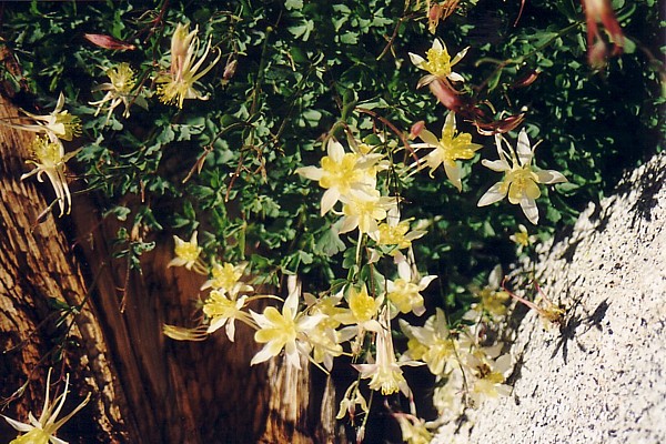
After a cool night's sleep, I awoke at 6:30, had a quick breakfast, and headed over the pass into the Kid Lake's basin. It was the second time I had entered the basin and this time it was considerably more pleasant than the last. I was welcomed by a beautiful bouquet of columbines and the absence of snow on the north side of the pass made the descent into the basin routine instead of perilous.
Columbines - A columbine bouquet near the pass welcomed me to the Kid Lakes.
Soon I was at Lake 10,620 and looking back toward Goat Mountain and the pass.

View from Lake 10,620 - Goat Peak and the pass form the skyline to the west from Lake 10,620 in the Kid Lakes basin.
I noticed a gully leading across to the other lakes and decided to check it out. From the ridge top there was a great view of the route into Glacier lakes, but the descent to the other side was steep and didn't make the crossing much of a short cut.

Route to Glacier Lakes - The route to Glacier Lakes came into view as I crested the ridge separating the southern lake from the canyon to the north.
I ascended Kid Creek and arrived at the scenic uppermost lakes.

Upper Kid Lakes - Goat Crest forms the backdrop for the uppermost Kid lakes.
Route finding across the divide was not difficult. I passed a lovely pond as I made my way down to the uppermost Glacier lake.

Pretty Pond -This lovey pond was about halfway between the pass and uppermost Glacier lake.
Views from uppermost Glacier lake are among the finest in the area.

Uppermost Glacier Lake - Spectacular views await the visitor to the uppermost Glacier lake.
I savored them during a rest stop then proceeded past Lake 10,429 to the ridge separating it from the western string of Glacier Lakes.

Lake 10,429 - It seems like this gem deserves a little better name than Lake 10,429.
These two sets of lakes are so isolated from each other that it's hard to imagine why they don't have different names. As I crossed the ridge, I took a shot of Glacier Valley and its meandering stream far below.

Glacier Valley - The ridge between the eastern and western Glacier lakes is a great vantage point for viewing the south fork of the East Fork of Dougherty Creek which meanders through the verdant Glacier Valley.
The western Glacier lakes felt remote and there were few signs of visitors. The uppermost lake had a fine view of the ridge separating it from the eastern lakes.

Uppermost Western Glacier Lake - The highest of the remote western Glacier lakes makes a wonderful destination.
Next was Lake 10,172, another fine destination.

Lake 10,172, another worthy destination.
The two large lakes are upstream from two miniature lakes, one a deep blue

Little Lake - Even the small lakes in this chain are lovely.
and the other fringed in grass.

Little Lake with Grass Fringe - The last of the lakes in the chain has a lovely fringe of grass.
The descent, steep at first, leads through forest to the trail that connects Granite Pass and Simpson Meadow. I found it just a few dozen yards south of the turnoff to Kennedy Pass. Once on trail, I headed quickly toward Volcanic Lakes, my destination for the evening. Dinner break was at a beautifully situated lake beside the trail.

Dinner Spot - I ate dinner at this small unnamed gem that lies across the Middle Fork of Dougherty from Glacier Lakes.
Briefly, I toyed with the idea of staying at this lovely spot but since there was plenty of light remaining, I pushed on to Volcanic Lakes. Mosquitoes began to plague me as I dropped toward the West Fork of Dougherty Creek and they continued to bug as I climbed past Lake 9,702. Fortunately, they began to thin out as I gained elevation and they were pretty much a bad memory by the time I found a camp spot a few hundred yards north of Lake 10,077.
Day 3
The next day, I awoke to clear skies and beautiful lighting.
Lake 10,077 - This was the morning view from my night two campspot just north of Lake 10,077 in the Volcanic Lake chain.
After a quick breakfast, I was on my way to the Monarch Divide. I walked past Lake 10,199

View across the mirror surface of Lake 10,199, my favorite photo of the trip.
and up to the highest lake in the chain.

Uppermost Volcanic Lake - The route over the Monarch Divide to Granite Lakes forms the backdrop for the highest of the Volcanic Lakes.
Having been into the basin a couple of times before on a route from Granite Pass, I decided it might be interesting to try something different. The crossing took more time than I thought it would but the views from the ridge top made the longer trip well worth it. Most of the Volcanic Lakes were visible to the north

Volcanic Lakes - What a great view of Volcanic Lakes, the Black Divide, and the Palisades. At the time, I thought that the crossing was not worth the effort, but the scenery made it worthwhile.
and Granite Lakes were to the south.

Granite Lakes from the Monarch Divide.
The descent into Granite Basin was a little steeper than I anticipated, but soon I was passing by the lowest visible lake in the chain and on my way out to Cedar Grove.

Lower Granite Lakes - When I first saw this lake in the lower Granite Basin in 1957, I was hooked on exploring the Sierra Nevada.
