In addition to its historical importance, Mt Brewer's location allows views of most of the major peaks of Sequoia and Kings Canyon National Parks. The approach and climb is not difficult. The Brewer Party's approach was a long one through the forest from the west. Today, a short approach from the Cedar Grove trail head allows the serious hiker to comfortably climb Brewer in a loop trip of three days.
The hike begins at the permit booth at road's end. The first couple of miles of trail is a slog through flat sand. A short descent into the South Fork Kings River flood plain brings the hiker to the Baily Bridge which crosses the river. Several more bridges are crossed, this time over Bubbs Creek, on the way to the base of the switchbacks that lead into Bubbs Creek Canyon.
The trail becomes gentle after passing the bridge that leads up Sphinx Creek to Avalanche Pass. It passes though alternating forest and brush with high canyon walls dominating views to the north and south. After the Charlotte Creek crossing, the canyon walls squeeze in. The trail remains on the north side of Bubbs Creek until Junction Meadow where it is crossed.

At lush Junction Meadow, Bubbs Creek is crossed and East Creek is ascended along a pleasant and well kept trail.
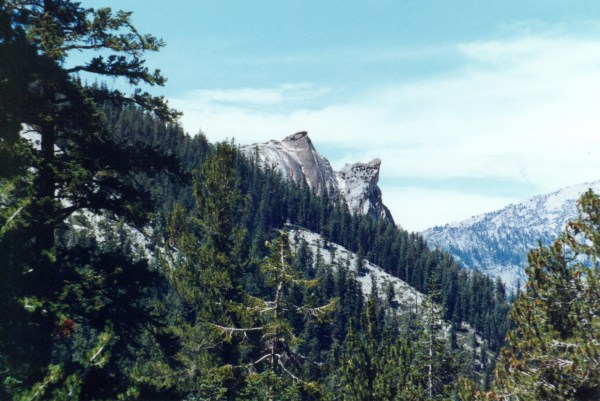
East Creek is ascended partly on switchbacks, to lovely East Lakewhere on a clear day, there is a marvelous view of our goal, Mt Brewer.

East Lake with Mount Brewer in the haze. - East Lake is an excellent destination on its own with its central location, fine campsites, good fishing,and two bear boxes. It makes a great base camp for climbing Mount Brewer if you don't want to loop through Sphinx Creek. In addition, lovely Lake Reflection is just up the trail. Unfortunately, Mount Brewer is more often in the haze than not. Is this because of my bad luck or is air pollution getting worse in this area?
There are numerous campsites and two bear boxes at East Lake. If there is light, continue hiking up Ouzel Creek so it will be easier to make the summit during the morning of the next day.

Mount Brewer in morning light from Ouzel Creek campsite - It's not easy finding a flat spot along this creek. Needless to say I had this area to myself. The day promised to be clear as I headed up the slope toward the summit.
As the summit is approached the next morning the way appears to be blocked.

Summit from the east - The way to the south slope from the east side is hidden until you get to it. Once there, it is a short hike to the base of the south slope.
Upon moving closer, a way to the south side of the mountain comes into view. Soon it is time to begin the ascent to the summit up the south side. Even with a pack, the ascent is not difficult. The forested plateau that the Brewer Party crossed to get here can be seen to the west.

Summit Block and View to the West - I searched everywhere for the register but couldn't find it. I even climbed over to the summit block and stuck my arm into all the cracks, but to no avail. Oh well, the views were great, including this one of Big Brewer Lake and the forested plateau that the Brewer Party crossed to get here.
To the south, the Kaweah Peaks can be seen in the distance, the Great Western Divide in the middle ground and South Guard and South Guard Lake in the foreground.

On this beautiful day, the view was clear in every direction. In the foreground is South Guard Lake. In the distance is the unmistakable bump of Black Kaweah next to the other Kaweah Peaks.
To the southeast lie the fourteen thousand foot peaks of the Whitney group.

The Brewer party was excited to see tall mountains to the southeast which included the tallest in the United States, Mount Whitney. The view of what was between it and them must have been quite intimidating. Nothing but miles of jagged rock can be seen in the intervening wilderness that separated them from the distant peaks.
The puddle to the east is East Lake.

East Lake and University Peak - The view to the east northeast includes East Lake at the bottom of the near canyon and University Peak on the skyline.
The view to the northeast includes the Palisades in the distance with the peaks of the Gardiner Basin in the middle ground and Charlotte Dome just on the other side of Bubbs Creek.

Charlotte Dome, Gardiner Basin, and The Palisades - On the skyline stands the dark presense of the Palisades, the other group of fourteen thousand foot peaks visible from Mt Brewer. Rising from the bottom of the deep canyon just beyond the buff colored rocks of the foreground is Charlotte Dome, a favorite haunt of climbers. Between these features is Gardiner Basin, named for a member of the Brewer Party as is the lofty peak on the south side of the basin. The east side of Gardiner Basin is bounded by peaks named for two other members of the party, Clarence King and Cotter.
The view to the north includes North Guard in the foreground with Mt Goddard and the Palisades on the horizon.

North Guard and Mt Goddard - Immediately north of Mt Brewer is North Guard and far in the distance on the sky line sits massive, dark, Mount Goddard. Goddard is similar to Brewer in that it sits west of the major divide and by itself, affording great views in every direction.
After taking in the marvelous views and taking photos, a descent down the north side is not difficult if there is not a lot of snow covering the slope. The talus is loose but not dangeous if you take your time.

The Northwest Side of Mt Brewer provides a fine slope to descend into the north fork of Brewer Creek. It is a little steep at first and I felt a little unstable with a full pack on the higher parts of the slopes.
The next leg of the trip involves some map work. The topo will guide you on a path that contours around to pass into the Sphinx Creek drainage.

Sphinx Pass - With a little map work, it is easy to contour around to the base of the pass into Sphinx Creek. My original plans for this trip were to return to the trail head from the summit by retracing my route. I was lucky to have an experienced trailhead ranger issue my permit. He suggested I return via Sphinx Creek and I'm sure glad he did.
The pass is easy if there is no snow in it and the descent into the Sphinx basin is a pleasant one decorated with patches of shooting star and yellow coumbine.
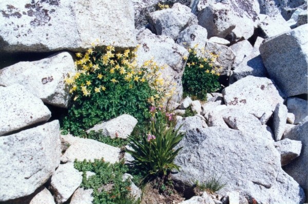
The High Gardens of Sphinx Creek - Before reaching the first Sphinx Lake, you must pass by the lovely clumps of yellow columbine and shooting star. The pass is easy from both sides.
After reaching the first lake in Sphinx Creek valley, the view to the south would include the pass you just crossed.

Sphinx Pass - It's as easy as it looks and those lovely flower gardens are between the lake and the pass.
You may notice some nice looking trout in the lakes. If you brought your fishing gear and its not too late, you will probably be able to catch dinner.
There are many lovely campsites next to the Sphinx Lakes. You will probably have company because this scenic area is very popular with cross country hikers as well as climbers on their way to or from Brewer and other nearby peaks.

This is one of my favorite views in the entire Sierra Nevada, the Sphinx Divide with its impressive horn piercing the azure sky. The granitic rocks of the area are particularly light and contrast beautifully with the deep blue of the lakes.
Watch out for marmots. One of them decided to make a meal of some of my gear and ate part of a plastic zipper out of my biouac sack before I chased him away. Even though the area is popular, you should be able to enjoy observing some fairly fearless creatures such as pikas, weasels, chipmunks, deer, and nuthatches. If you are lucky, you might be serenaded by a hermit thrush, my favorite singer in these parts. Since the return to the trailhead from Sphinx Lakes takes only a few hours you can spend the next morning fishing, resting, exploring or just soaking in the fabulous views of the Spinx Divide and the Monarch Divide.

Largest of Sphinx Lakes from the East - Since it doesn't take all day to return to the trail head, you have a little time to explore. I walked to the east end of the lake in the photo and up to the little tarn that drains into it. I found some campsites way over here in a grove of pines. Talk about solitude with a great view, this is it.
If it's fairly clear, you may be able to see Mt Goddard far to the north.

The view to the north hints that the upper Sphinx Lakes are at timberline which is true. This is my favorite elevation/biome in the Sierras. It seems that there is an abundance of wildlife at this transition into the more barren zones of higher elevations.
If you have never descended Sphinx Creek, I recommend staying on the west side. I have tried both ways and the east side is quite brushy and broken up by periodic talus fields. There is a lot of evidence of travellers on the west side and you should have little trouble finding your way down. Eventually you will intersect the Avalanche Pass trail. After crossing Sphinx Creek, the trail descends the Sphinx Creek valley down its east side. After a relatively gentle descent on an impressive moraine covered by fragrant forest, the trail drops via switchbacks to the bottom of the canyon. On the way down there are great views of The Sphinx, named by John Muir for its resemblance to the one in Egypt.
After passing two other lakes, the cross country route becomes more distict. Finally the Avalance Pass Trail is intersected, Sphinx Creek is crossed to its east side and soon The Sphinx is in view. Since this trip was my first on this trail, I was spellbound by The Sphinx.
The next section passes through sage and penny royal. Some of the most impressive trail work in the range is built on the nose of steep, smooth granite the trail wraps around. The trail drops, ocassionally via stairs, into Bubbs Creek canyon. There are great views both up Bubbs Creek

Charlotte Creek can be seen. Charlotte Creek has cut the dark gash into the north canyon wall. An excellent cross country route up Charlotte Creek leads to the base of Gardiner Pass and into the Gardiner Basin, a cross country hiker's paradise.
and down canyon.

Looking down Bubbs Creek you can see that the creek is in hanging valley. Bubbs Creek falls into Kings River Canyon (south fork) via a series of spectaclar and noisy falls. The trail zig-zags down the slope north of Bubbs Creek, occasionally getting close enough to the falls to enjoy the tumult of the raging stream. In late afternoon, the descent can be similar to an hour on the top shelf of a sauna. At Baily Bridge, a soak in the toe waters of Bubbs Creek is a necessity if it is one of those late season blistering days.
After crossing the log bridge over Bubbs Creek, the loop is closed and a couple of hours hiking returns you to the starting point.