Nine Lake Basin
8-13 August 2012
by Bill Finch
Kaweah Queen or Bust. For the past five years or so, I have promised myself to bag this 13,388 ft peak that is the northern flank of Pyra-Queen Col. Each attempt has ended in failure, including this one. I did see some beautiful country and experienced some freaky weather. In addition, I managed to see an abundance of flowers, even in this exceptionally dry year.
Day 1
The trip started at Crescent Meadow as usual. I got as early a start as possible on a beautiful day. Clouds had started build up by the time I arrived at the exceptional view of the Great Western Divide just past Mehrten Creek.

This is one of the most dramatic vistas on the first section of the HST.
My pace got slower and slower and by the time I reached Bearpaw Meadow I couldn't go any farther. I set up camp and visited with others in the campground until bedtime.
Day 2
The next morning I made my way toward Kaweah Gap and talked to many hikers along the way including a group from Florida who were going all the way to Mount Whitney. By the time I reached Hamilton Lake, most of the camp sites had been taken.

The view across the lake is one of the most spectacular in Sequoia.
I talked with the Floridians some more who were really dreading the switchbacks that were visible from the lake. Their concern must have rubbed off on me so I made camp at the upper penthouse and socialized for the rest of the day. That evening, a trail crewman announced that they would be blasting up the trail near the bridgesite and we had two choices. We could get up early and hike past the blast site or we could wait until the blasting was complete and start our hike then. I opted for sleeping in even though the day's hiking had been minimal.
Day 3
At the beginning of my third day, about 20 of us waited for the blasting to be completed. We enjoyed visting during breakfast and finally it was time to take cover just in case a stray rock from the blast came flying through the campsite. After the "all clear" was pronounced, I stepped from behind the large Lodgepole Pine that was my cover to see a small cloud of rock dust from the blast. A half hour later I met the trail crew near the blast site and talked them into posing for a formal photo.

These guys work hard and are constanly making the trail safer and more pleasing in appearance.
The condition of trails in Sequoia and the High Sierra Trail (HST) in particular is a testimony to their hard work and dedication. A few steps beyond their work site, I came upon what may be the largest clump of explorer's gentian on the HST.

Every time I hike this trail, I look forward to this clump of flowers.
It wasn't the only clump I saw during the trip - gentians didn't seem to be bothered by the drought as much as many other kinds of flowers. I continued toward Kaweah Gap, passing chinquapins in catkins,

This photo was taken at an elevation of about 10,000 ft which I thought was about the upper limit for chinquapin. However, Calphoto puts the upper limit at 12,000 ft.
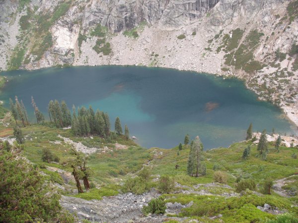
the unnamed lake below Precipice Lake,

Usually this lake has some snow around it, even in August.
and an impressive clump of alpine gentian.

This is the first time I have noticed this lovely flower in this area. They were widespread between Precipice Lake and Kaweah Gap as well as in the Nine Lake Basin.
At lunchtime I was on the pass eating lunch and shooing away a marmot who begged for treats.

This pesky marmot got as close as my boots. I'll bet he has tasted lots of human food but he didn't get any of mine.
The Nine Lake Basin was a beautiful as usual.

Kaweah Queen is not visible from here, but much of the Basin and Big Arroyo are.
After a few minutes hiking, I left the HST and headed crosscountry to the foxtail pine forest on the moraine east of "Horseshoe" Lake. I found a great spot, set up camp, and finished another easy day.
Day 4
On the morning of the fourth day, I stuffed essentials into my pack and headed for Kaweah Queen. While climbing toward my destination, I passed by clumps of monkey flowers that were unaware that this was a drought year.

I sure didn't expect to see these mimulus up here.
Rocks became shattered and sharp and talus seemed endless.

I've fallen on rocks like these before and it takes a while for the cuts to heal.
I had some lunch at the bench above "Butch" Lake (the large, unnamed lake in the shadow of Black Kaweah) and headed toward the saddle between Kaweah Queen and Lawson Peak.
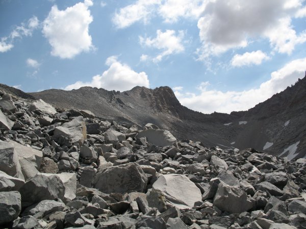
It seemed like the weather changed pretty quickly, but I probably didn't notice because I was concentrating on crossing endless talus.
A few hundred feet below the saddle, it began to rain, then hail. Kaweah Queen was shrouded in clouds.

Oh well, I can always try again next year.
I sat beneath my umbrella for an hour or so and decided it wasn't going to clear any time soon. Thunder and lightning contined all around me. About an hour after I headed back to camp, it began to clear, and soon I had a great view of the forest, Eagle Scout Peak, and Kaweah Gap.

What the heck. This basin is a worthy destination by itself.
That evening I was treated to a lovely sunset.

It still hadn't cleared off that evening.
Day 5
The morning of day five involved talking to neighbors and hikers passing through the forest. Late that morning I was atop Kaweah Gap again with a view even cloudier than a couple of days earlier.

I sure didn't expect the downpour that was to come less than an hour later.
As I reached Precipice Lake, the clouds burst open and let loose a furious storm of rain and hail.

Mud flowed down the trail from above.
There was nothing to do but keep on going. The storm didn't look like it would be ending soon, so I took out my umbrella and continued down the trail. I noticed a plume of sediment building out into Hamilton Lake from the stream that goes through the pine forest on the lake's north shore.

I've seen sediment plumes from the Mississippi and Mekong Rivers, but never before one into an alpine lake.
The plume continued to grow and was joined by a smaller one to the west.

Soon, I noticed that, in addition to the fine sediment plume, organic debris had been washed into the lake.
The larger plume extended half way across Hamilton Lake. Floating debris formed two brown patches on the surface.
It was amazing to see how fast the plume moved through the water.
As I reached the camp by the western lake shore, the storm renewed its fury. A little rain fell, but mostly the storm was felt a strong wind from the east which soon blew the floating debris from the nearest stream to the shore. Leaves and bark, a foot or more deep, lapped at the shore and the surf was definitely up. Whitecaps covered the lake. A few campers, disgusted with the stormy weather huddled in their tents or under tarps. I continued heading out with the goal of making it to Lone Pine Creek or Bearpaw. By the time I made it to Lone Pine Creek, I was tired and decided to stay there. I made camp at the site above the old stream crossing and it was a good thing. At dark, a group came along and asked if there was water nearby. I directed them down the trail to the creek and asked them if they knew about the campsite toward the bridge that is surrounded by manzanitas. Someone else had told them about the hidden site but they weren't sure that it was big enough for their group of five with four tents.
Day 6
The morning of the last day, a member of the group of five came up the trail. Apparently the site had been adequate. The previous day, they had meant to hike crosscountry from the Tablelands toward Elizabeth Pass but they got stuck in talus they didn't like. They decide to descend to the HST but instead of going down Buck Creek, they went down Nine Mile Creek. They all agreed it was a route that they would never take again. Soon, I was on the trail on this my sixth and final day. It got warmer as I headed west, so I drank plenty of water and doused my hat every chance I got. Lunch was at Mehrten Creek where I talked to an Jeff, an enologist from Santa Rosa, who shared my opinion on just about every hiking issue we talked about. He must be really intelligent. A couple of hours before ending the hike, I returned to the canyon oasis where I had seen dozens of different flowers including the rarely encountered giant hellebore.

This is the only place I have seen Epipactis gigantea, giant hellebore or stream orchid, a lovely orchid rarely found in the Sierra Nevada.
The last couple of hours seemed to drag by, but soon enough I felt the joy of sighting Moro Rock, then the thrill of entering Giant Forest at the end of another adventure on the High Sierra Trail.

free website hosting reviews
25 August 2012
One Page Version 19 January 2013