Day 1
7/10/872pm Upper Paradise Valley
Hiked 11 miles since beginning at the trailhead east of Cedar Grove. I have six or eight miles to go. Got on the trail at 9:45 this morning. Signs for this trip seemed ominous. I forgot to water the garden last night so I had to do it this morning. As I was leaving the house, I noticed that the front door had been egged. It took 20 minutes to clean up that mess. I tried to buy wet-wipes at the market but they didn't have any. As I was driving up the grade, I remembered that I hadn't sent in a letter of protest for a huge increase in property taxes on our Colorado property. All these omens reinforced feelings of foreboding I've been having about this trip for the last few days. I'm glad the life insurance is paid up. One of the reasons I'm concerned is because this is a very long trip of 76 miles. This hike is a big loop from Cedar Grove road's end trailhead up Paradise Valley, Woods Creek, Pinchot Pass, Upper Basin, Mather Pass, Palisade Creek, Middle Fork of the Kings River, Simpson Meadow, Granite Pass and back home. I originally planned it as a four day trip, but I think I'll extend it to five.
6:30 Just finished a cup of soup after arriving at my camp spot which is 1.5 miles north of the Woods Creek crossing.

It's a nice spot next to the river. I covered 18.5 miles in about 8 hours and 45 minutes. I'm tired but not whipped.
Day 2
7/11/87Woke up at 5:35. It was very warm last night. I could have brought a lighter sleeping bag. Thank God for good mosquito repellent.
On the trail at 6:50.
Passed the turnoff to Sawmill Pass at 8:00. I saw at least three good camps between here and Woods Creek.
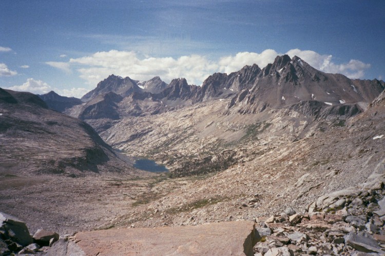
OnPinchot Pass at 10:30.

[View north from Pinchot Pass.]

Stopped for lunch below Marjorie Lake at about noon.

Crossed the South Fork of the Kings at 1:23.
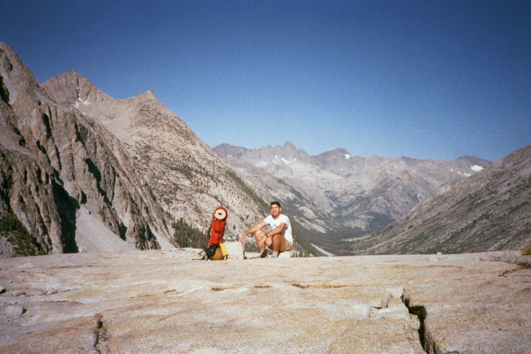
At the base of Mather Pass at 4:00 and on top at 4:35. [View to the south from Mather Pass]

Arrived at camp east of Upper Palisade Lake at 6:10. Pretty tired. I guess I'd better take it easy tomorrow if I don't feel good. Upper Basin is not pretty enough to be a destination. I'm not as impressed with the Palisades as I thought I'd be.
They are neat and everything, but the view doesn't come close to the Kaweah Peaks. Next trip I'm going to take it easy and go to Gardiner Basin. This is not the easiest way to see the John Muir Trail.
Day 3
7/12/87Up at 5:35. Feel Great. I had a bath and changed clothes. Slept on top of sleeping bag in my bivvy bag. Too hot otherwise. Temp this morning almost 60 degrees. Clouded over for the first half of the night then cleared.
On the Trail at 7:25. Trout are feeding on the lake below. It's odd. There just aren't many people up here.
8:40 Great view of Devil's Crags from the top of the Golden Staircase.
9:35 Deer Meadow
11:15 Middle Fork trail junction. The bridge over Palisade Creek is washed out.

11:50 Falls on Middle Fork Kings. This may be pretty in its own way, but I doubt if I'll come this way again.
12:45 Cascades into river above first bend. Four hikers behind me.
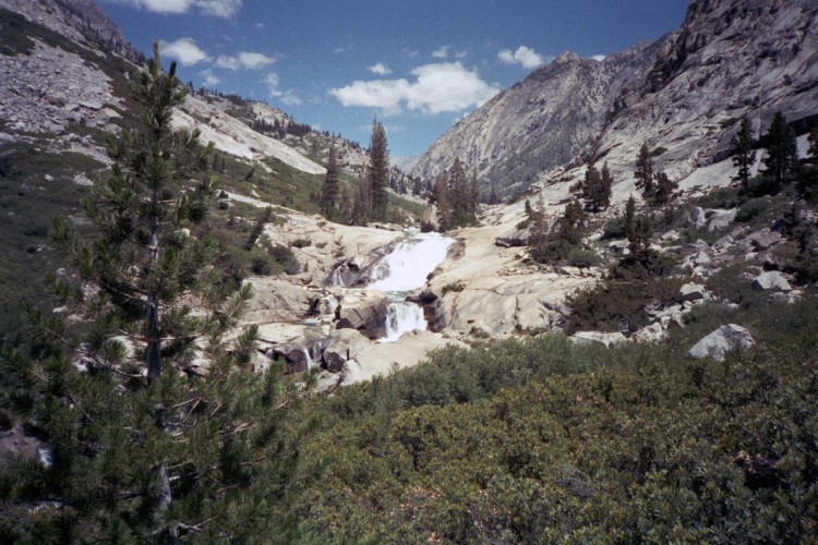
1:05 Falls on the MF Kings. [Devil's Washbowl]

1:30 Breccia volcanic? Area dominated by metavolcanic rocks containing epidote.
1:50 Cartridge Creek. Sign says JMT 5 miles Simpson Meadow 4.2
3:46 Simpson Mdw fork in trail.
4:24 Took wrong fork. Didn't see sign that said Tehipite Valley. The route I took leads to a crossing of the river via a large log below the washed out bridge. Sign says JMT 9 miles.
6:00 Finished with dinner and ready to go. Met 3 people doing the reverse of my route. Said trail is dry all the way to the top for 3 or 4 miles. Simpson Meadow is hot, dry, fly-ridden disappointment.
8:45 Made camp at Dougherty Mdw fork. Lots of mosquitos, just like everyone has said. Thank God for the folks who told me it's a long dry stretch from Simpson Mdw to first water. I haven't reached water yet, but the extra 3 pints I brought in my canteen saved me from dehydration.
Day 4
7/13/87Woke up at 5.
Out of bag at 5:30.
Breakfast of Tang and banana bread. Will try to hit the trail by 6.

8:00 East Dougherty Mdw. Simp Mdw 7 Granite Pass 5. Mosquitos incredible. If old trail doesn't have water, the new trail is a better way to come from Simpson to Dougherty.
8:30 States Lake Trail
9:30 Trail Junction Granite Ps 2.9 Trailhead 13.8 Volcanic Lakes 2 etc.
11:25 Granite Pass
1:45 Trail sign says Granite Pass 1
12:10 Lunch. Feel very tired.
2:25 Granite Basin pass
4:10 Lower Tent Meadow 5.6 to Road's End. It has been sprinkling from the top of the ridge down to here.Keeps the bugs down.
5:50 Road's End.
[Reflections on this trip 19 years later (25 March 2006)
I took this trip in an attempt to section hike the John Muir Trail. It became obvious to me after this trip and completion of the Rae Lakes Loop a few weeks earlier, that section hiking the JMT was not the way to go. Some of the observations I made at the time have changed through the passing years. I have revisited Simpson Meadow and don't find it the hell hole I described it in this report. The upper Middle Fork does hold a certain charm and certainly it has some spectacular scenery. However, I have tended to avoid lower elevation canyons since this trip. I learned a lot about fatigue and how quickly recovery comes when you are in good shape. Completion of this hike encouraged me to plan and complete the JMT in 13 days, just a few weeks after completing this one.]